

Vous suivez désormais
Erreur de suivi de l'utilisateur.
Cet utilisateur n'utilise pas les utilisateurs à le suivre.
Vous suivez déjà cet utilisateur.
Votre plan d'adhésion ne permet que 0 suivis. Améliorez ici.
Ne suit désormais plus
Erreur lors de l'arrêt du suivi de l'utilisateur.
Vous avez désormais recommandé
Erreur lors de la recommendation de l'utilisateur.
Une erreur a eu lieu. Veuillez rafraîchir la page et réessayer.
E-mail désormais vérifié.

lahore,
pakistan
Il est actuellement 2:26 AM ici
Rejoint le juillet 13, 2017
0 Recommandations
Muneeb A.
@MUNEEBAAMIR
0,0
0,0
0%
0%
lahore,
pakistan
N/A
Travaux complétés
N/A
Suivant le budget
N/A
Dans les temps
N/A
Taux de réembauche
Geospatial Expert
Contactez Muneeb A. concernant votre travail
Connectez-vous pour discuter de tous les détails via la messagerie.
Portfolio
Portfolio


Preparation of Digital Elevation Model
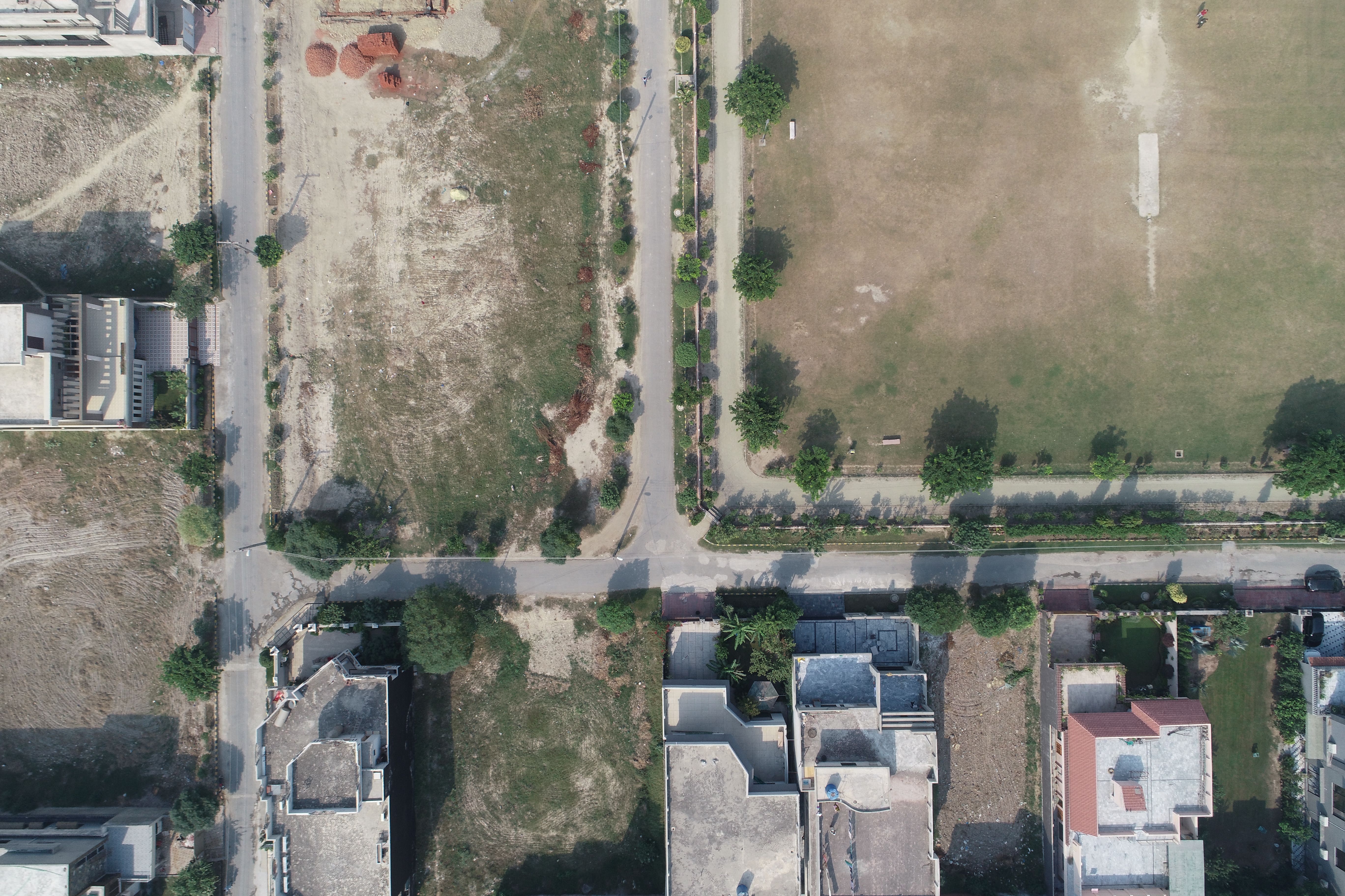

Drone Mapping

Drone Mapping

Drone Mapping
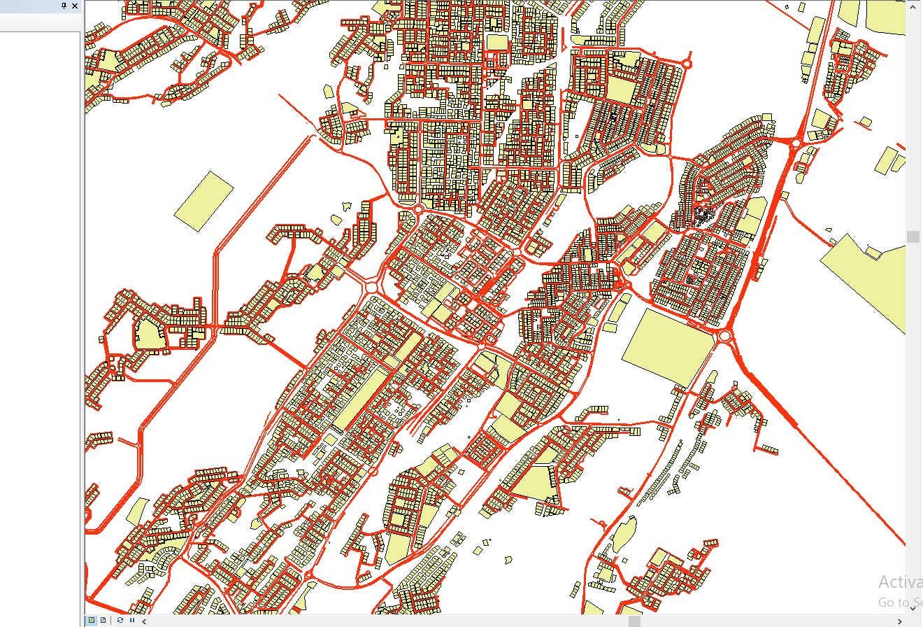

CAD to SHP Files

CAD to SHP Files
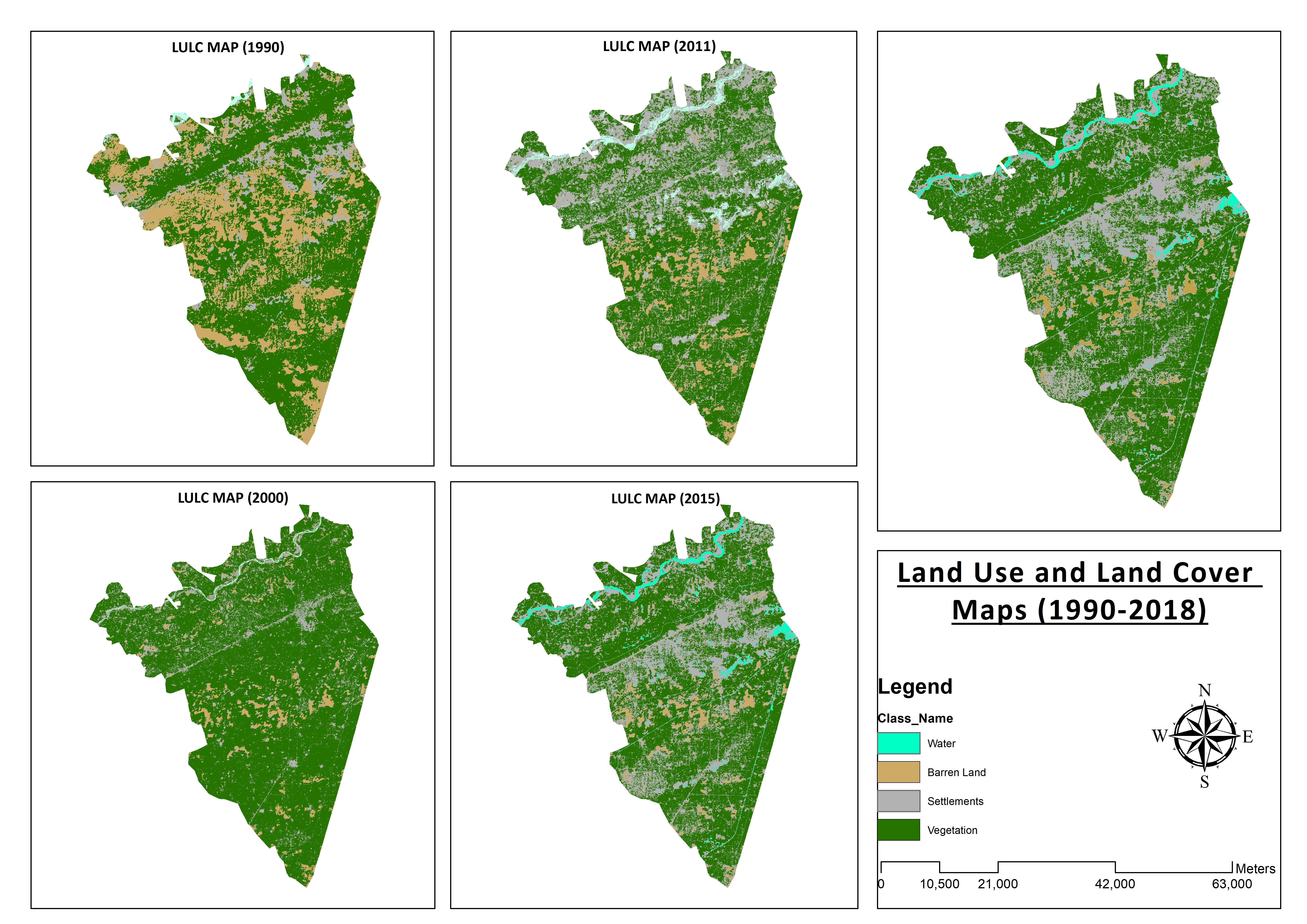

Land Use and Land Cover Maps
Preparation of Digital Elevation Model
Drone Mapping
Drone Mapping
Drone Mapping
CAD to SHP Files
CAD to SHP Files
Land Use and Land Cover Maps
Commentaires
Modifications enregistrées
Aucun commentaire visible ici !
Expérience
Remote Sensing and GIS Analyst
sept. 2018 - oct. 2019 (1 an, 1 mois)
Developed, integrated and Implemented GIS and Geodesy based Topographic Survey Plans under different Hydro-Power Projects in Northern Pakistan, Extension of Canal Projects to increase its capacity in Sindh-Balochistan, Analysis of Suitable Site Selection for different development sites by using Drone for Aerial Mapping and their detailed pre-feasibility studies with different softwares, to analyse and interpret spatial data to produce interacting Maps and Reports while ensuring quality control.
Research Associate GIS
oct. 2015 - oct. 2018 (3 ans)
Deployed GIS-based system under Urban Immovable Property Tax (UIPT) for Punjab Excise & Taxation Department. Provided comprehensive support in creating the system while take advantage of software suites like ArcGIS Suite and ERDAS Imagine. Prepared communicating maps to help surveyors in Analyzing geo-spatial data to verify it during ground truthing. Created shapefiles to merge topographical data with external data through layering process.
Éducation
Master of Philosophy in Geographic Information System
(2 ans)
Bachelors in Geographic Information System
(4 ans)
Qualifications
MS-Office
TEVTA
2017
MS-Office Certification in MS-Word, Excel and Power Point.
Publications
Analysis of Flood Damage Assessment through Different Satellite Datasets in Southern Punjab,Pakistan
International Journal of Innovations in Science & Technology
RS and GIS techniques can achieve the objectives and significant analyses through visual interpretations. These techniques are also used to identify the flood affected regions. The study site was examined by applying supervised classification determining that 16900.96 Hectors of agriculture land was damaged while Sparse Riverine Forest had the area 44.52 hectors. The damaged built-up area was 1805.78 Hectors.
Estimation of Net Rice Production by Remote Sensing and Multi Source Datasets
Sarhad Journal Of Agriculture
Estimation of net crop production before harvest enables agronomists and decision makers to determine the volume of grain precisely. Yield estimation is one of the challenging tasks which is significant to evaluate accurately for farmers. This research was conducted in eastern Punjab Pakistan by incorporating yield/area as reported by Crop Reporting Service Department along with open source satellite datasets.
Contactez Muneeb A. concernant votre travail
Connectez-vous pour discuter de tous les détails via la messagerie.
Vérifications
Meilleures compétences
Parcourir les freelances similaires
Parcourir les présentations similaires
Invitation désormais envoyée !
Merci ! Nous vous avons envoyé un lien par e-mail afin de réclamer votre crédit gratuit.
Une erreur a eu lieu lors de l'envoi de votre e-mail. Veuillez réessayer.
Échec de copie dans le presse-papier, veuillez réessayer après avoir ajuster vos permissions.
Copié dans le presse-papier.
Chargement de l'aperçu
Permission donnée pour la géolocalisation.
Votre session de connexion a expiré et vous avez été déconnecté. Veuillez vous connecter à nouveau.