

Vous suivez désormais
Erreur de suivi de l'utilisateur.
Cet utilisateur n'utilise pas les utilisateurs à le suivre.
Vous suivez déjà cet utilisateur.
Votre plan d'adhésion ne permet que 0 suivis. Améliorez ici.
Ne suit désormais plus
Erreur lors de l'arrêt du suivi de l'utilisateur.
Vous avez désormais recommandé
Erreur lors de la recommendation de l'utilisateur.
Une erreur a eu lieu. Veuillez rafraîchir la page et réessayer.
E-mail désormais vérifié.

serra,
brazil
Il est actuellement 5:20 PM ici
Rejoint le septembre 8, 2015
0 Recommandations
Everton R.
@alotus
0,0
0,0
0%
0%
serra,
brazil
N/A
Travaux complétés
N/A
Suivant le budget
N/A
Dans les temps
N/A
Taux de réembauche
Cartography, GIS and CAD Designer
Contactez Everton R. concernant votre travail
Connectez-vous pour discuter de tous les détails via la messagerie.
Portfolio
Portfolio
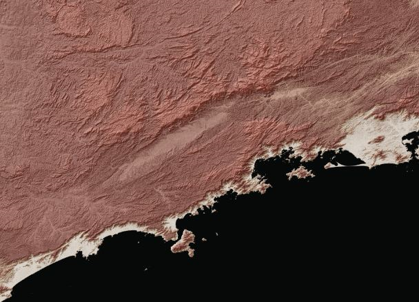

Relevo Sombreado


Relevo Sombreado
Relevo Sombreado
Relevo Sombreado
Commentaires
Modifications enregistrées
Aucun commentaire visible ici !
Expérience
Coordenador de Processamento de Dados
févr. 1992 - Jusqu'à présent
I work with mapping and data processing. Created the cartographic database used in the study of environmental maps throughout Brazilian coast. I produced the shaded relief in satellite images used in environmental studies. I produced the bathymetry of the Brazilian coast from nautical charts. I manage 3 linux servers with more than 5 terabytes of data. I manage two mail servers and two Linux firewalls. System developed in Microsoft Access + Visual Basic geophysical compensation, asset control.
Contactez Everton R. concernant votre travail
Connectez-vous pour discuter de tous les détails via la messagerie.
Vérifications
Meilleures compétences
Parcourir les freelances similaires
Parcourir les présentations similaires
Invitation désormais envoyée !
Merci ! Nous vous avons envoyé un lien par e-mail afin de réclamer votre crédit gratuit.
Une erreur a eu lieu lors de l'envoi de votre e-mail. Veuillez réessayer.
Échec de copie dans le presse-papier, veuillez réessayer après avoir ajuster vos permissions.
Copié dans le presse-papier.
Chargement de l'aperçu
Permission donnée pour la géolocalisation.
Votre session de connexion a expiré et vous avez été déconnecté. Veuillez vous connecter à nouveau.